O HAI! You must login or signup first!

Karen-mon-am

Submission   48,641

Part of a series on Karen. [View Related Entries]


Overview

Tropical Storm Karen is a tropical storm which began developing in the Atlantic Ocean in September of 2019. Upon the spread of news about the developing tropical storm, Twitter users joked about the name of storm by connecting it to jokes about the Karen character who appears in memes as an angry, middle-aged white woman who often demands to "speak to the manager."

Background

On September 22nd, 2019, the National Hurricane Center[1] reported a tropical storm had formed in the Atlantic Ocean, and issued a warning for St. Vincent and the Grenadines, along with Grenada and its territories. That day, meteorologist James Spann[2] tweeted about the development, warning it could turn westward and hit the United States (shown below).


James Spann @spann Tropical Storm Karen has formed in the Atlantic. It will move generally northward in coming days; there is some risk it will turn westward, back toward the U.S., in 5-7 days as a ridge builds north of the system. contains the probable path of the storm center but does not show e storm. Hazardous conditions can occur outside of the cone. ahesas 10 -2 AM Fri heras 0 -2 AM Thu 84 24 36 12 48 60 72 96 108 120 132 Forecast Period (hr) 2 AM Wed Use ofh rodu govemed by the UCAR Tems of Use wwardutems-use ue w NCAR POTENTIAL TROPICAL CYCLONE INVEST (AL12) 2 AM Tue 5 AM Sun NCEP GFS Ensemble track guidance initialized at 0000 UTC, 22 September 2019) 2 PM Mon Curent Intensity 30 Curent Basin: Noth Atantic 2 AM Mon 45% Venen Gol 4 6OW 75W 70W 65W 5W ,50w 45W 40W Forecast positions: Tropical Cyclone O Post/Potential TC Current information: x Center locatian 11.9 N60.2 W Maimum sustainod wind 40 mph Movement WNW at 9 mph 25 D39 mph Sustained wirds: S 39-73 mph H74-110 mph M110 mph Warnings: Watches: Current wind extent: 15h Huricare Trep St Trop Stm Hucaner Trap Stm Huricane 10% 7:32 AM Sep 22, 2019 Tweetbot for Mac Forecast Intensity

Developments

In response to Spann's tweet, Twitter users began making jokes about the storm by referencing the Karen meme. User Parker Molloy[3] photoshopped a stereotypical "Karen" haircut onto a map of the storm's trajectory, gaining over 90 retweets and 590 likes (shown below, left). User @JWButta[4] joked the cone behind the height of the storm represented "the rising anger of everyone in line behind #Karen as she argues with the manager because her coupons are not working," gaining over 820 retweets and 3,500 likes (shown below, right). "Karen" jokes about the tropical storm were covered by Time[5] and Twitchy.[6]
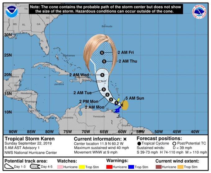
Note: The cone contains the probable path of the storm center but does not show the size of the storm. Hazardous conditions can occur outside of the cone. TN noRn MS GA AL Bermuda 30N 2 AM Fri 25N amas -2 AM Thu 20N AM Wed HATominitan S Mexico BepublPe Jamáica Bellid Guatemal> 15N Salvstor 2 AM Tue- Honduray 5 AM Sun 2 PM Mon 2 AM Mon Nicaragus 10N Venezuela Colombia Guydna 55W 90W 85W 65W 40W 80W 75W 70W 60W 50W 45W Tropical Storm Karen Sunday September 22, 2019 5 AM AST Advisory 1 NWS National Hurricane Center Forecast positions: Tropical Cyclone O Post/Potential TC Sustained winds: S 39-73 mph H 74-110 mph M> 110 mph Current information: x Center location 11.9 N 60.2 W Maximum sustained wind 40 mph Movement WNW at 9 mph D 39 mph Potential track area: Day 1-3 Day 4-5 Warnings: Watches: Current wind extent: Hurricane Hurricane Trop Stm Trop Stm Hurricane Trop Stm
MeltLikeButta @JWButta This Forecast Cone is an actual visual representation of the rising anger of everyone in line behind #Karen as she argues with the manager because her coupons are not working. FORECAST CONE KAREN ains H gh Pressure Bermuda Fri 2:00 AM 3 mph Alantic Ocean South Florida Galfo Mako gh Pressure High Thu 2:00 AM 60 mph Wed 200 AM s0 mph Tue 200 AM 40 mph Lesser Antilles Caribbean Sea 7:43 AM Sep 22, 2019 Twitter Web App res

Search Interest

External References


Share Pin

Related Entries 26 total

Managerhaircutt
"Speak to the Manager" Haircut
Karen
Karen Generation
Snl-black-jeopardy
Raisin Potato Salad
Karens-1
Y'all Were Raised By Karens? ...


Recent Images 6 total


Recent Videos 0 total

There are no recent videos.


Load 6 Comments
Tropical Storm Karen

Tropical Storm Karen

Part of a series on Karen. [View Related Entries]

Updated Sep 23, 2019 at 12:39PM EDT by Adam.

Added Sep 23, 2019 at 12:20PM EDT by Adam.

PROTIP: Press 'i' to view the image gallery, 'v' to view the video gallery, or 'r' to view a random entry.

This submission is currently being researched & evaluated!

You can help confirm this entry by contributing facts, media, and other evidence of notability and mutation.

Overview

Tropical Storm Karen is a tropical storm which began developing in the Atlantic Ocean in September of 2019. Upon the spread of news about the developing tropical storm, Twitter users joked about the name of storm by connecting it to jokes about the Karen character who appears in memes as an angry, middle-aged white woman who often demands to "speak to the manager."

Background

On September 22nd, 2019, the National Hurricane Center[1] reported a tropical storm had formed in the Atlantic Ocean, and issued a warning for St. Vincent and the Grenadines, along with Grenada and its territories. That day, meteorologist James Spann[2] tweeted about the development, warning it could turn westward and hit the United States (shown below).


James Spann @spann Tropical Storm Karen has formed in the Atlantic. It will move generally northward in coming days; there is some risk it will turn westward, back toward the U.S., in 5-7 days as a ridge builds north of the system. contains the probable path of the storm center but does not show e storm. Hazardous conditions can occur outside of the cone. ahesas 10 -2 AM Fri heras 0 -2 AM Thu 84 24 36 12 48 60 72 96 108 120 132 Forecast Period (hr) 2 AM Wed Use ofh rodu govemed by the UCAR Tems of Use wwardutems-use ue w NCAR POTENTIAL TROPICAL CYCLONE INVEST (AL12) 2 AM Tue 5 AM Sun NCEP GFS Ensemble track guidance initialized at 0000 UTC, 22 September 2019) 2 PM Mon Curent Intensity 30 Curent Basin: Noth Atantic 2 AM Mon 45% Venen Gol 4 6OW 75W 70W 65W 5W ,50w 45W 40W Forecast positions: Tropical Cyclone O Post/Potential TC Current information: x Center locatian 11.9 N60.2 W Maimum sustainod wind 40 mph Movement WNW at 9 mph 25 D39 mph Sustained wirds: S 39-73 mph H74-110 mph M110 mph Warnings: Watches: Current wind extent: 15h Huricare Trep St Trop Stm Hucaner Trap Stm Huricane 10% 7:32 AM Sep 22, 2019 Tweetbot for Mac Forecast Intensity

Developments

In response to Spann's tweet, Twitter users began making jokes about the storm by referencing the Karen meme. User Parker Molloy[3] photoshopped a stereotypical "Karen" haircut onto a map of the storm's trajectory, gaining over 90 retweets and 590 likes (shown below, left). User @JWButta[4] joked the cone behind the height of the storm represented "the rising anger of everyone in line behind #Karen as she argues with the manager because her coupons are not working," gaining over 820 retweets and 3,500 likes (shown below, right). "Karen" jokes about the tropical storm were covered by Time[5] and Twitchy.[6]


Note: The cone contains the probable path of the storm center but does not show the size of the storm. Hazardous conditions can occur outside of the cone. TN noRn MS GA AL Bermuda 30N 2 AM Fri 25N amas -2 AM Thu 20N AM Wed HATominitan S Mexico BepublPe Jamáica Bellid Guatemal> 15N Salvstor 2 AM Tue- Honduray 5 AM Sun 2 PM Mon 2 AM Mon Nicaragus 10N Venezuela Colombia Guydna 55W 90W 85W 65W 40W 80W 75W 70W 60W 50W 45W Tropical Storm Karen Sunday September 22, 2019 5 AM AST Advisory 1 NWS National Hurricane Center Forecast positions: Tropical Cyclone O Post/Potential TC Sustained winds: S 39-73 mph H 74-110 mph M> 110 mph Current information: x Center location 11.9 N 60.2 W Maximum sustained wind 40 mph Movement WNW at 9 mph D 39 mph Potential track area: Day 1-3 Day 4-5 Warnings: Watches: Current wind extent: Hurricane Hurricane Trop Stm Trop Stm Hurricane Trop Stm MeltLikeButta @JWButta This Forecast Cone is an actual visual representation of the rising anger of everyone in line behind #Karen as she argues with the manager because her coupons are not working. FORECAST CONE KAREN ains H gh Pressure Bermuda Fri 2:00 AM 3 mph Alantic Ocean South Florida Galfo Mako gh Pressure High Thu 2:00 AM 60 mph Wed 200 AM s0 mph Tue 200 AM 40 mph Lesser Antilles Caribbean Sea 7:43 AM Sep 22, 2019 Twitter Web App res

Search Interest

External References

Recent Videos

There are no videos currently available.

Recent Images 6 total